Fire

Cerro Pelado Fire Update: Sunday May 29, 2022

USDA Forest Service News:

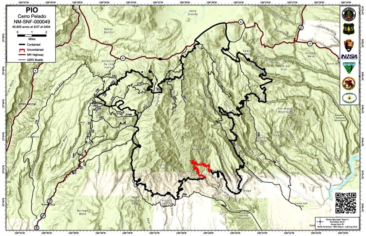
The Cerro Pelado Fire remains at 45,605 acres and 95 percent containment.

Today on the northwest side of the fire, crews will continue to patrol the perimeter and mop up deep into the interior of the fire perimeter when it’s safe to do so. Hand crews and heavy equipment continue suppression repair on the west side of the fire.

Local and incident resources on the eastern side of the fire will continue to patrol the fire’s perimeter while assisting with any needed initial attack that arises.

Today will be another day with red flag warning conditions. With critical fire weather Read More

Luján Meets With Leaders In Mora On Wildfire Recovery

U.S. Sen. Ben Ray Luján meets with local leaders Mora County Commission Chair Veronica Serna, Mora County Manager Michael Rivera, Mora Emergency Manager David Montoya, Sheriff Amos Espinosa, Under Sheriff Americk Padilla and Robert Baca of the Mora-San Miguel Electric Cooperative. Courtesy photo

STATE News:

MORA — U.S. Sen. Ben Ray Luján (D-N.M.) met Thursday with county and local officials in Mora to discuss the historic wildfires that rage across the state and mitigation efforts to ensure affected New Mexicans can recover and rebuild from these disasters as quickly and strongly as possible. Read More

Cerro Pelado Fire Containment Increases To 95 Percent

Courtesy/USDAFS

USDA Forest Service News:

Temperatures will continue to increase over the Cerro Pelado Fire area with relative humidity remaining in the single digits. Fire activity has been minimal along the perimeter. The fire has not spread for several days, even under adverse weather conditions.

The northwest side of the fire, near the Jemez Falls, has completed back haul of fire suppression equipment. The crews will mop up deep into the interior of the fire perimeter when it’s safe to do so. The section of the fire referred to as “the horseshoe” has been contained increasing containment Read More

BAER Specialists Complete Analysis Of Cerro Pelado Fire

BAER Specialists News:

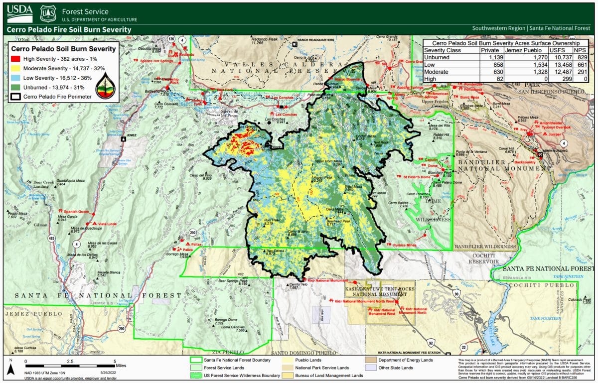
SANTA FE – Burned Area Emergency Response (BAER) specialists from the USDA Forest Service and the US Department of Interior assessment teams have completed data gathering and analysis for the Cerro Pelado Fire.

SANTA FE – Burned Area Emergency Response (BAER) specialists from the USDA Forest Service and the US Department of Interior assessment teams have completed data gathering and analysis for the Cerro Pelado Fire.

The soil burn severity (SBS) map analyzes approximately 45,605 acres of the burned area. The map and the data display soil burn severity (SBS) categories Read More

Wildfire Preparedness Is Year-Round … Recreate Responsibly To Help Prevent Human-Caused Ignitions

SFNF News:

SANTA FE — As we gather to honor our fallen heroes this Memorial Day weekend and into the summer, support firefighters and protect your community by preventing additional wildfire ignitions.

We are experiencing historic levels of fire danger, and restrictions and closures are in place in many areas across the state to prevent wildfires. Many public lands are either in elevated levels of restrictions or are closed to public access entirely.

This month, you can do your part by learning about restrictions and area closures across the state before you plan your weekend and summer activities Read More

Gov. Michelle Lujan Grisham On Cause Of Calf Canyon Fire: ‘Pain And Suffering … Is Unfathomable’

From the Office of the Governor:

SANTA FE – Gov. Michelle Lujan Grisham issued a statement following the announcement by the U.S. Forest Service that a federal pile burn holdover ignited the Calf Canyon Fire, which merged with the Hermits Peak Fire to become the largest fire in New Mexico history:  

“The pain and suffering of New Mexicans caused by the actions of the U.S. Forest Service – an agency that is intended to be a steward of our lands – is unfathomable.

“This is a first step toward the federal government taking full responsibility for the largest wildfire in state history, which has destroyed Read More

Cerro Pelado Post-Fire BAER SBS Map Released

Courtesy/USDAFS

BAER Specialists News:

SANTA FE – Burned Area Emergency Response (BAER) specialists from the USDA Forest Service and the US Department of Interior assessment teams have completed data gathering and analysis for the Cerro Pelado Fire.

The soil burn severity (SBS) map analyzes approximately 45,605 acres of the burned area. The map and the data display soil burn severity (SBS) categories of unburned/very low, low, moderate, and high. Approximately 67 percent of the acres are either unburned/very low or low SBS, while 32 percent sustained a moderate SBS and only 1 percent identified Read More

Investigators Determine Cause Of Calf Canyon Fire

USDA Forest Service News:

SANTA FE – Forest Service fire investigators have determined that the Calf Canyon Fire on the Pecos/Las Vegas Ranger District of the Santa Fe National Forest (SFNF) was caused by a pile burn holdover from January that remained dormant under the surface through three winter snow events before reemerging in April.

A holdover fire, also called a sleeper fire, is a fire that remains dormant for a considerable time.

Smoke was reported April 9 from the vicinity of the Gallinas Canyon Wildland Urban Interface pile burn, which had concluded Jan. 29, and crews responded. Crews Read More

Cerro Pelado Fire Update For Friday May 27, 2022

USDA Forest Service News:

The USDA Forest Service released the following update this morning on the Cerro Pelado Fire:

With critical fire weather expected over this holiday weekend, the Rocky Mountain Incident Management Team 3 would like to remind the public to be safe with fire and observe all closures and fire restrictions.

Temperatures will continue to increase over the fire area with lower relative humidity in the single digits. Fire behavior continues to be minimal across the fire area.

Crews will continue work on the northwest side of the fire near the Jemez Falls area. The crews will Read More

Los Alamos County Opens Some Trails For Public Access … Stage 3 Fire Restrictions Remain In Place

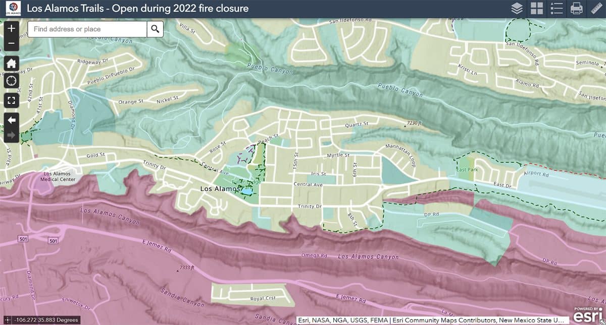
Click this link: interactive online map to find open trails, including paved trails in Los Alamos & White Rock. Courtesy/LAC

COUNTY News:

Los Alamos County Fire Chief and Fire Marshal are opening some County owned trails for public access during Stage 3 fire restrictions beginning today, May 27.

Now that the Cerro Pelado fire is more than 90 percent contained, Fire Department officials have had an opportunity to evaluate the County trail network and determined some trails can be opened for limited access.

Trails opening as part of the amended order include:

Read More